
Places
Ma Pi Leng, the pass everyone photographs
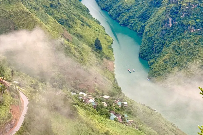
Ma Pi Leng (Mã Pì Lèng) is the mountain pass road cut into the cliff between Dong Van and Meo Vac, running roughly 500 metres above the Nho Que river (Nho Quế) below. It is the single most photographed stretch of the Ha Giang Loop, and the place I got properly lost on, on my own mountain, a few years ago.
What Ma Pi Leng actually is
It is a road, cut into the side of a limestone cliff, connecting Dong Van (Đồng Văn) and Meo Vac (Mèo Vạc) — one of the well-known mountain passes in northern Vietnam. The Nho Que river runs far below it, a thin green line most of the way down the gorge. Every version of the loop I run crosses it, because there is no way to see this part of Ha Giang without doing so.
The night I got lost here
I have told this story on the about page in full, but it belongs here too, because it is the reason I take this specific stretch of road seriously. A few of us went looking for a viewpoint nobody had photographed yet, starting from the Nho Que river too late in the afternoon. The ridge between Bản Mồ and Thiên Hương climbs like the spine of an animal — one rise after another — and it started raining as we climbed. We packed dry leaves around ourselves in a crack in the rock to stop the wet cloth pulling the heat out of us, reached the top in the dark with no way down, and only got off the mountain because Hmong families farm those slopes, and where there is maize there is a path. We walked it through the forest, in the rain, on red mud, most of the night.
I did not learn that from a guiding course. I learned it because I grew up under this mountain, and it still caught me out.
Why I tell guests this story
When I say we are turning back, waiting out a morning, or not taking a particular road on Ma Pi Leng, it is not caution for its own sake. I know exactly how fast this place stops being beautiful and starts being dangerous, because it has happened to me.
Ways to actually see it
Riding across it is the default — every one of my trips does this, easy rider or self-drive. Beyond that:
- From the road itself, stopped at a viewpoint, looking down at the gorge — the version almost everyone sees.
- From the river, looking up — a boat or raft on the Nho Que, which the Ha Giang to Cao Bang route includes.
- From the cliff itself, overnight — Forest & Stone camps on the white cliff of Ma Pi Leng, which is the only way I know of to actually be there at first light rather than arriving after the buses do.
When it looks its best — and when it doesn't
Clear mornings in the dry months (September to November, March to May — the full breakdown is in when to visit Ha Giang) give you the gorge in full, the river visible the whole way down. In the wet season the cloud sits in the valley for days at a time and you can lose the view entirely — worth knowing before you build a trip around a single photograph.
Next step
Ride it, or camp on it
Every one of my trips crosses Ma Pi Leng. If you want to actually sleep on the cliff rather than just stop for a photo, Forest & Stone is the one that does that.